|
Arctic and Antarctica
Reference:
Ginzburg, A.P., Lupachev , A.V. (2025). Geomorphological structure and several physico-chemical properties of soils in Western Spitsbergen maritime cryogenic landscapes. Arctic and Antarctica, 1, 60–81. . https://doi.org/10.7256/2453-8922.2025.1.72689
Geomorphological structure and several physico-chemical properties of soils in Western Spitsbergen maritime cryogenic landscapes
Ginzburg Aleksandr Pavlovich
ORCID: 0009-0006-0424-547X
Postgraduate student; Laboratory of Soil Cryology; Pushchinsky Scientific Center for Biological Research of the Russian Academy of Sciences
2/2 Institutskaya str., office 23, Pushchino, Moscow region, 142290, Russia

|
alexandrgiznburg13154@yandex.ru
|
|
 |
|
Lupachev Aleksei Vladimirovich
ORCID: 0000-0003-0116-8828
PhD in Biology
Senior Researcher; Laboratory of Soil Cryology; 'Pushchino Scientific Center for Biological Research' of the Russian Academy of Sciences
142290, Russia, Moscow region, Pushchino, Institutskaya str., 2/2, office 23
|
|
a.lupachev@gmail.com
|
|
 |
|
DOI: 10.7256/2453-8922.2025.1.72689
EDN: QXWIQK
Received:
12-12-2024
Published:
22-03-2025
Abstract:
Spitsbergen is the territory with unique landscape, geological and biological diversity under threat of degradation as a consequence of air temperature dynamics and permafrost area and thickness decrease. Additionally, nowadays in Spitsbergen the mining activity continues (coal, metal ores, hydrocarbons) and the quantity of tourists rises yearly. These reasons unavoidably lead to ecosystem transformation processes. In 2024 field studies of soils and natural waters at Western Spitsbergen cryogenic landscapes took places around Green-Fjord (Barentsburg) and Colesbay (Polar station). 19 soil profiles were described and classified as 8 types. Soil were described according to classification and diagnostics of Russian soils. Soil peats studies were carried out by the landscape-geochemical (catenar) principle. In soil cover structure of the elevated geomorphological levels – I and II marine terraces (including those covered by deluvial shields), – gleyic cryozems and humified petrozems dominate. Soil surfaces on these levels are complicated by nano-polygonal cryogenic microrelief. Soil diversity of lower geomorphological levels – river floodplains and low (periodically flooding) accumulative sea coasts, – is presented by pelozems, petrozems, and sulfide solonchaks, developing in conditions of shallow dense rocky layer depth. Major part of studied natural waters is characterized by moderate oxidation-reduction potential around 100-250 mV, acidity rate vary within 6.5-9.5. Mineral-peaty gleezems developing in the lowlands with the periodical flooding by sea waters are characterized by the highest acidity rates and compose negative oxidation-reduction potential (down to -3 mV) and high mineralization (between 3-5 g L-1). Soils of these landscapes are most perspective from the point of lateral matter migration in catenas of the Spitsbergen maritime cryogenic landscapes for the reason that contrast lateral geochemical barriers are able to form here.
Keywords:
Permafrost, Cryogenic processes, Cryozem, Lithozem, Petrozem, Buried soils, Natural waters geochemistry, Acidity, Mineralization, Oxidation-reduction potential
This article is automatically translated.
You can find original text of the article here.
Introduction The territory of the Svalbard Archipelago is one of the few regions of the European Arctic sector where permafrost rocks (MMP) are common not only in the highlands, but also in low–lying coastal areas, most heavily occupied by vegetation and exposed to anthropogenic impact [1]. These landscapes occupy up to 70% of the area of non-glacial spaces here [2-3]. MMPs were formed here in the tertiary period [4] and currently, along with widespread cryogenic processes, are an important factor in the formation and functioning of the soil cover of landscapes [5]. In this regard, the current dynamics of cryolithozone development in the region, primarily an increase in the thickness of the active layer against the background of an increase in average annual air temperatures [6-7], can significantly affect the soils of the coastal–marine cryogenic ecosystems of Svalbard. The modern soil cover of Svalbard has been studied by Russian [8-13] and foreign specialists [14-18]. A significant part of the soils in mountainous areas is highly lithogenic, poor in fine-grained, poorly grained, underlain at shallow depths by a rocky base and often characterized by the absence of glacial permafrost in the profile. These factors determine the relatively low diversity of the soil and vegetation cover in these geomorphological conditions. The coastline of the seas and adjacent land areas, on the contrary, are among the most complexly organized, geochemically active, dynamically developing and vulnerable components of ecosystems [19], including in Svalbard. The penetration of seawater deep into the land during tidal surges, the formation of a drying zone during runoff winds, the introduction of allochthonous organic and mineral matter, salinization of soil profiles and thawing of the upper permafrost horizons, combined with a wide range of soil and cryogenic processes in conditions of close occurrence of permafrost rocks, have a large-scale impact on the formation of unique and diverse cryogenic soil complexes and the underlying permafrost [20-21]. Cryogenic soils and the underlying upper horizons of permafrost rocks (permafrost complexes – PMCs [22]) are the most important element of the functioning of polar biomes in areas with close (about 1 m) occurrence of MMP. The structure, properties and functioning of the soil cover and the permafrost situation largely determine the geochemical features of polar landscapes in terms of mobilization, transit and accumulation of various elements and compounds capable of migration in soil profiles: their redistribution due to soil formation and cryogenic mass transfer, further horizontal migration along the surface of the permafrost barrier with permafrost runoff, penetration and cryopreservation in the thickness of the upper layers of the MMP, removal to surface reservoirs and coastal marine areas. In the conditions of modern climatic changes, the structure of the structural elements of the PMK and their interrelation undergo significant changes: previously frozen transitional and intermediate layers of the MMP are involved in the modern biogeochemical cycle [23]; soil formation processes transform with changes in the bioclimatic parameters of the environment and penetrate to a greater depth; a relatively more powerful active layer is included in the zone of biological activity, etc. Of particular interest in this regard is the study of PMCs in regions with high-temperature, dynamic MMPs, such as Western Svalbard. The main purpose of the work is to provide a preliminary characterization of the soil and geomorphological structure of coastal and marine landscapes and to study the spatial distribution of some physico-chemical properties of soils and natural waters, as well as the cryolithological properties of the upper horizons of the MMP elementary geochemical landscapes of Western Svalbard. The first results of morphological and physico-chemical studies of soils and underlying MMPs during field work at the end of July 2024 on the island of Western Spitsbergen in the area of the village of Barentsburg (Gren Fjord Bay and Kolsbey Bay) are presented. Objects and methods of research Objects. The research was carried out at two key sites – the coast of the Gulf of Grenfjord in the area of the village of Barentsburg (Fig. 1) and the coast of Kolsbey Bay in the Bay of Isfjord near the polar station of the same name. In the coastal lowlands of the shores of the Gulf of Gren Fjord, 12 soil sections were laid in various landscape, geomorphological and geocryological conditions, and 4 sections in the area of the Kolsbey peninsula. 
Fig. 1. Research area (a) and key areas on it (b). 1 – key research areas: South coast hall. Gren Fjord (A), M. Finniset (B), delta of the Graendalselva River (C), buh coast. Kolsbey (G). 2 is the cryosphere testing ground of the Russian Scientific Center at the arch. Svalbard. Physical and geographical conditions of the Svalbard archipelago Climate. The average annual air temperature in Barentsburg is -3.8°C. The frost–free period lasts about 100 days, the growing season is 40-70 days. The sum of temperatures >10°C does not exceed 400-450°C. Up to 565 mm of precipitation falls per year [24]. In winter, a snow cover with a thickness of 1.5-2 m and a density of 350-500 kg/m3 is installed [25]. Quaternary deposits and modern relief. The thickness of the friable Quaternary sediments of Svalbard is 50-60 m. It is represented fragmentarily in tectonic and erosive depressions and in the coastal lowlands [26-27]. The lithogenic basis of coastal-marine landscapes consists of marine and glacial-marine sediments of the Upper Pleistocene and Holocene ages [27]. About 12-10 thousand . years ago, there was a powerful marine transgression, the sea level exceeded the modern level by 40-65 m. As a result, marine sediments are very widespread in the lowlands [28]. About 60% of the territory is occupied by mountain and mountain valley glaciers with a total area of 35,528 km2. Glacial exaration and accumulation actively transform the relief, moving and depositing large volumes of rocks [29]. South coast hall. Isfjord, including the hall. Gren Fjord and the boom. Kolsbey is the territory with the most active deglaciation within the entire archipelago: the total area of glaciers does not exceed 10 km2, and the loss of glacier area reaches 0.7–1%/year [30].
Geocryological conditions. The average thickness of the cryolithozone reaches 300 m [31]. The distribution of MMPs is characterized as continuous [3, 32-33], but in the coastal lowlands and in large river valleys, MMPs are discontinuous and intermittent [34]. At a depth of zero seasonal amplitudes (about 20 m [35]), temperatures vary from -5 to -2°C [36]. At the cryosphere range of the Russian Scientific Center in the Svalbard archipelago (KP RNTSH, fig. 1) at a depth of 15 m, the average annual temperature of the MMP for 2015-2016 was -2.37°C [37]. The thickness of the seasonally thawed layer (CTC) at the CALM sites on Western Svalbard Island varies from 60-70 to more than 250 cm [38]. At KP RNTSH, the STS capacity is 110-260 cm. Vegetation cover. Due to the warming influence of the North Atlantic current, the flora of Svalbard is quite diverse for the High Arctic region. In total, 167 species of vascular plants, approximately 380 species of mosses and lichens, and more than 700 species of algae are known in the archipelago [39]. The Barentsburg area has a number of plant associations typical of the Central Arctic zone, the composition of which varies depending on the lithological and geomorphological features of the territory [14]. Methods. Soil sections were laid in key areas to the depth of dense rocks, the roof of the MMP, or the groundwater level (UGV). The description of soils was based on a field determinant [40]. By reaction with a solution of yellow blood salt (K4[Fe(CN)6]) the intensity and relevance of the gluing were qualitatively established. An automatic probe thermometer was used to measure soil temperature in 10 cm increments. Sampling was carried out horizontally. Skeletal (gravelly) The CF – coarse fraction was determined in the dry state as the weight fraction of coarse soil (particles larger than 1 mm in diameter) in the total mass of the sample. The calculation was performed using the formula: CF, % = (MT – MFF)/MT ∙ 100; where MT is the total mass of the dry sample, MFF is the mass of fine–grained (FF – fine fraction) particles with a diameter of >1 mm. The physicochemical parameters of natural waters of various origins were studied at 26 points (4 in marine waters; 2 in backwaters; 3 in lakes; 2 in wells; 4 in rivers and streams; 2 in thawed snow and ice waters; 10 in groundwater).: temperature (T), acidity (pH), total content of easily soluble salts (TDS) and redox potential (Eh). The measurements were carried out with automatic portable electrodes HM Digital (Hydromaster Inc., Republic of Korea): COM-100 (T, TDS), PH-200 (pH) and ORP-200 (Eh), as well as a portable multimeter HI 98127 Combo (Hanna Instruments inc., Germany). The analysis of the distribution patterns of the studied physico-chemical properties was carried out according to the catenary principle. The names of elementary geochemical landscapes (EGL) are given in accordance with the classification of M.A. Glazovskaya [41] as presented by M.D. Bogdanova et al. [42] (Table 1). The contrast distribution and the possibility of formation of lateral geochemical barriers were estimated by the value of the coefficient of lateral differentiation (L), calculated by the formula: Lx = Cx PL/Cx AL; where Cx PL is the value of parameter x in the subordinate EGL, Cx AL is the value of parameter x in the autonomous (eluvial) EGL [41]. Table 1. Explanation of abbreviated names of EGG types. | EGL type (index) | Shapes and elements of relief shapes | | Eluvial (E) | Flat watershed surfaces, convex peaks, above-floodplain terraces, clearly defined in relief | | Transeluvial (TE) | Slopes of varying steepness | |
Transaccumulative eluvial (TAE) | Above-floodplain terraces overlain by deluvial plumes, divided terraced slopes | | Transit periodic superquality (TC) | High and medium floodplains | | Superquality Transit (ST) | Low floodplains | | Aqualny (A) | Rivers , etc. water bodies | Results The key area is "The Southern shore of the Gulf of Gren Fjord" (77°57'51.85" S; 14°18'30.16" H) Lithologically, the landscapes of the key site "A" are largely formed by the accumulative material of the glacier. Most of the area of the southern shore of the bay is occupied by a large KMG, in which deep erosion furrows have been washed by temporary watercourses, and strata of proluvial material have accumulated (Fig. 2B). There are no visual signs of soil salinity or halophilic vegetation typical of saline marches. In contrast to the soils on the seashore accumulative shore, the waters in the SVB-24-08 section on the low floodplain are more mineralized (TDS = 1,342.5 mg/l). Currently, their thickness is being eroded by a stream flowing down from the Vostochny Gren Fjord glacier, the salinity of which exceeds 5,000 mg/l in the lower reaches (Fig. 2B). 
Fig. 2. Landscape and geomorphological profile (A) and cartography (B) of the key site "Southern shore of the Gulf of Gren Fjord". The relief forms are: 1 – course-moraine ridge, 2 – erosion furrows, 3 – cone of outflow, 4 – marine accumulative shore, 5 – low floodplain, 6 – beach. The lithological composition of the sediments: 7 – sandy and sandy loam marine, 8 – loamy glacial-marine with pebbles and crushed stone, 9 – loamy glacial with boulders, 10 – gravelly proluvial, 11 – sandy with pebbles and crushed stone glacial-marine, 12 – loamy marine, 13 – individual finds of large boulders. Vegetation: 14 – sorrel, 15 – mosses, 16 – cereals, 17 – lichens, 18 – willows. Elementary geochemical landscapes: 19 – first–order eluvial with a predominance of lateral migration + transeluvial with active outflow, 20 – transaccumulative, 21 - transit–accumulative, 22 – transit periodically superaqueous, 23 – superaqueous transit; 24 - profile along the A1-A2 line, 25 – soil sections. Most of the territory of the entire key site is devoid of closed vegetation cover. On stone pavements, the landscapes of which were formed on the flat gently sloping surfaces of the cones of outflow, oxalic-moss-lichen vegetation grows in cracks between boulders and clusters of pebbles (Fig. 2A). The surface of the high floodplain has a much higher percentage of projective vegetation coverage. In the elevated part of the floodplain, the vegetation association is represented by willow-moss-grassy and grassy-moss-lichen tundras, and in a shallow depression, moss-grassy vegetation occurs on this floodplain (Fig. 2A). The soil surface on the high floodplain is almost completely covered with small (up to 20 cm in height) moss hummocks, which alternate with wide parallel bands of sea retreat at a short distance from the coast. The described soils were classified as lithozems of coarse humus (section SVB-24-10), petrozems of humus (section SVB-24-02, SVB-24-07 and SVB-24-09) and secondary salt marshes on buried coarse humus soils (section SVB-24-08). Most of them are characterized by skeletons above 50%, with the exception of the upper part of the secondary salt marsh profile, in which a large fraction occupies only 19% of the total mineral mass.
In the lower part of the SVB-24-07 soil profile there is a loamy horizon with a thickness of 10 cm, characterized by reduced skeletonism (47.7%) and thixotropy. This horizon is clearly morphologically expressed and is similar to the horizon of the soil-forming rock in the buried profile of coarse humus soil (section SVB-24-08). Cape Finniset Key Area (78°2'36.26" C; 14°13'42.80" H) Two soil sections were laid at the key site "B" on the Finnisset m. 3 km south of the village of Barentsburg. Geomorphologically, this territory is an elongated promontory protruding into the sea, formed by the active removal of glacial, glacial-marine and fluvioglacial material by a temporary watercourse. The northern part of the cape is elevated by 7-10 m above sea level, it is cut through by several V-shaped deep ravines (Fig. 3B), in the sides of which layers of piled fluvioglacial sandy loams alternate with peat are exposed. The southern part of the cape is low–lying, with an average height of no more than 2-3 m above sea level. Most of its surface is characterized by a significant degree of anthropogenic transformation: there is an archaeological site – a whaling complex of the late 19th and early 20th centuries [43-44]. Higher up the slope, the landscapes of the beach and the accumulative seashore are replaced by a wide deluvial plume (Fig. 3A) and a steep (about 30°) slope partially covered with moss-grass vegetation, on which there are scree areas. In the deluvial plume section, the structure of the SVB-24-05 soil section demonstrates a clear division into two layers: the upper loamy one containing a small amount of pebbles (deluvial), and the lower one with sandy fine–grained soil containing up to 75% pebbles (glacial-marine) (Fig. 3). The profile of the SVB-24-06 section is less than It is clearly divided into horizons lithologically. This section was laid on a wetter surface than the deluvial plume, composed of glacial-marine sands containing up to 82% coarse fraction. The species composition of vegetation varies slightly between the sites of the two soil sections, however, the surface of the deluvial plume near the SVB-24-05 section is more hummocky, which is a sign of the initial stages of cryogenic heaving of loams (Fig. 6b). 
Fig. 3. Landscape and geomorphological profile (A) and cartography (B) of the Cape Finniset key site. Relief forms: 1 – II marine accumulative terrace, 2 – partially crumbling root slope of the II marine terrace, 3 – deluvial plume of the slope, 4 – V-shaped erosive incisions (ravines), 5 – gentle slope of the I marine terrace, 6 – marine accumulative shore, 7 – floodplain of the stream, 8 – beach. The lithological composition of the sediments: 9 – bedrock, 10 – coarse–grained deluvial, 11 – loamy with pebbles and gravel deluvial, 12 - sandy with pebbles glacial–marine, 13 – sandy marine, 14 - individual finds of large boulders. Vegetation: 15 – mixed grasses, 16 – mosses, 17 – grasses, 18 – willows. Elementary geochemical landscapes: 19 – second-order eluvial, 20 – transeluvial with active outflow, 21 – transaccumulative, 22 – transit-accumulative, 23 – transit periodically superaqueous, 24 – superaqueous transit; 25 – aquatic; 26 – profile along the line B1-B2; 27 – soil sections. Key area "Graendalselva River Valley" (78°1'31.57" S; 14°18'44.52" H) The key site "B" in the valley of the Graendalselva River is located 5 km south-east of the village of Barentsburg on the right bank of the river near its confluence with the hall. Gren Fjord (fig. 4). II the sea terrace is partially covered by a deluvial plume, the main part of which is located lower down the slope (Fig. 4B). The coarse-grained loamy deposits of the deluvial plume in the section contain morphological manifestations of cryoturbation in the form of curved boundary lines between soil horizons, as well as the presence of large hummocks and mineral spots-medallions on the surface. The soils of such habitats were diagnosed as gleevate cryozems (section SVB-24-12) (Fig. 6a). 
Fig. 4. Landscape and geomorphological profile (A) and cartography (B) of the key site "Valley of the river Graendalselva". Relief forms: 1 – II marine terrace, partially overlain by a deluvial plume, 2 – deluvial plume, 3 – gentle slope of the I marine terrace, 4 – high floodplain, 5 – marine accumulative shore, 6 – medium floodplain, 7 – low floodplain, 8 – riverbed. The lithological composition of the sediments: 9 – bedrock, 10 – coarse-grained-loamy deluvial, 11 – sandy-loamy with pebbles and alluvial soil, 12 – sandy with pebbles and alluvial soil, 13 – loamy-sandy marine. Vegetation: 14 – mixed grasses, 15 – mosses, 16 – grasses, 17 – lichens, 18 – willows; 19 – sedges, 20 – pickles. Elementary geochemical landscapes: 21 – second-order eluvial, 22 – transeluvial with moderate outflow, 23 – transeluvial-accumulative, 24 – transit periodically superaqueous, 25 – superaqueous transit, 26 – aquatic; 27 – profile along the B1-B2 line; 28 – soil sections. Further down the slope, a transition of the deluvial plume is observed in the section of the lower part of the gentle slope of the I marine terrace. The plant association does not change significantly during this transition; species of the sedge family drop out of its composition and cereals play a major role (Fig. 4A). Key area "Shore of Colsbay Bay" (78°6'22.29" C; 15°1'29.31" H)
Kolsbey Bay is located about 18 km east of the village of Barentsburg at the confluence with the hall. The isfjord of the Kolselva and Sunna rivers (Fig. 5). Most of the studied key area is located in a wide valley formed by their lower reaches. The low floodplains are swampy, and some of their areas are composed of modern marine light and medium loams, in which gluing is clearly evident, as evidenced by their color, lack of structure, viscosity, signs of new formation of sulfides, and other characteristics. The surface of the floodplain is covered with a grid of fractured polygonal relief, despite the relatively high winter temperatures in the area. The vegetation of the high floodplains is the most diverse, dominated by moss-lichen-grasses. Higher up the slope, willow and variegated grasses fall out of the association, while mosses and grasses occupy the dominant positions. The slopes of the valley are gentle and stepped. Artificial terracing of the slopes was probably carried out near the Kolsbey settlement and the adjacent buildings of the mine and the core storage facility to stabilize the supports of the water supply system. 
Fig. 5. Landscape and geomorphological profile (A) and cartography (B) of the key area "Kolsbey Bay Shore". Relief forms: 1 – II sea terrace, 2 – gentle slope of II sea terrace, 3 – I sea terrace, 4 – gentle slope of I sea terrace, 5 – high floodplain, 6 – bottoms of temporary watercourses, 7 – low floodplain, 8 – beach; Lithological composition of sediments: 9 – bedrock, 10 – coarse-grained-loamy deluvial, 11 – sandy-loamy with pebbles and gravel proluvial-deluvial, 12 – sandy with pebbles and gravel alluvial-marine, 13 – sandy alluvial-marine, 14 – sandy-loamy marine. Plant associations: 15 – moss, 16 – lichen, 17 – sedges, 18 – grasses, 19 – willow; 20 – mixed grasses, 21 – solyanka; Elementary geochemical landscapes: 21 – second-order eluvial, 22 – transeluvial with moderate overgrowth, 23 – transeluvial-accumulative, 24 – transit periodically superaqueous, 25 – superaqueous transit, 26 – aquatic, 27 – profile along the G1-G2 line; 28 – soil sections. The soils of the high floodplains, both connected to the side of the valley and their isolated areas, have a complex structure. The SVB-24-16 section (Fig. 6a) is a combination of horizons, indicating a sharp change in the stages and nature of soil formation. The upper part of the section is structurally similar to the soil with a gray humus horizon AY. Its horizons react weakly with a solution of blood salt and contain reddish spots in the lower part of the horizon. Below is the horizon [GsC], which is almost black, stained with iron sulfides, and reacts violently with a solution of blood salt. Below it is the permafrost horizon [Gss]┴ with numerous inclusions of soil. The roof of the MMP is located at a depth of 75 cm from the soil surface, so that the entire complex soil profile can be classified as permafrost. 
Fig. 6. Diversity of landscapes and soil profiles of various relief levels of the coastal lowlands of Western Svalbard, studied in 2024: a) deluvial plume – gleevate cryozem; b) deluvial plume – humus pelozem; c) I marine terrace – typical petrozem; d) marine accumulative (periodically flooded) shore – silty gleezempeat saline; e) high floodplain – coarse humus permafrost soil; f) low floodplain – grey humus permafrost soil on a buried sulfide permafrost salt marsh; g) isolated saline depression on a marine accumulative (periodically flooded) shore – sulfide permafrost salt marsh. The SVB-24-18 section is a system of soil profiles, the upper of which has horizons AYg and Cf. The gray-humus gleam horizon of AYg, in the near-surface part of which there is also a bright red zone with a thickness of about 1 cm. It, in turn, lies on a buried profile, which in structure resembles a coarse-humus cryozoam with a combination of horizons AO, CR┴ and the underlying C┬. Therefore, the soil structure has the form AYg – Cf – [AOg, f – CRf┴] – C┬ (Fig. 6e). Physico-chemical properties of natural waters Table 2 shows the main physico-chemical parameters of natural waters within the landscapes of Western Svalbard studied in 2024. They form the geochemical features of landscapes, as well as the internal relationships between various EGLS. Table 2. Variation of physico-chemical parameters of the natural waters of the Svalbard archipelago, studied in 2024 | Parameter | pH | Eh, mV |
TDS, g/L | | Water | By type of water | | Marine (n = 6) | 8,5 ± 0,4 | 121,7 ± 19,7 | 3,6 ± 2,1 | | Lakes (n = 4) | 8,0 ± 0,6 | 191 ± 35,1 | 0,17 ± 0,19 | | Riverine (n = 4) | 8,3 ± 0,4 | 155,8 ± 35,3 | 0,86 ± 1,43 | | Ice/snow (n = 2) | 8,3 ± 0,4 | 134,5 ± 92,6 | 0,04 ± 0,01 |
| Unpaved (n = 11) | 7,7 ± 0,6 | 174,5 ± 73,2 | 1,02 ± 1,59 | | Levels | By geomorphological levels | | Watersheds and automorphic surfaces of marine terraces (n = 1) | 8,4 | 187 | 0,083 | | Steep slopes of terraces (n = 2) | 8,2 ± 0,4 | 186 ± 8,5 | 0,134 ± 0,09 | | Gentle slopes, including on deluvial plumes (n = 2) | 7,5 ± 1,0 | 179,7 ± 96,0 | 0,3 ± 0,23 |
| High floodplains (n = 6) | 8,1 ± 0,5 | 149 ± 30,8 | 0,18 ± 0,10 | | Low floodplains (n = 11) | 7,9 ± 0,5 | 176 ± 77,1 | 0,18 ± 0,10 | | Marine accumulative (periodically flooded) shores (n = 6) | 8,5 ± 0,4 | 121,7 ± 19,7 | 3,63 ± 2,12 | Note: the average value in the table cells is ± the standard deviation. STS capacities and cryogenic textures of the upper layers of frozen rocks Within the studied area, the STS power was recorded at depths from 80 to 115 cm. Relatively shallow depths of seasonal thawing were most often observed in areas where sediments of a heavy granulometric composition are widespread and a sedimentary sediment-grass and/or moss-peat cover is developed – on slightly sloping relief surfaces in automorphic positions or close to them. On slopes with sparse vegetation and on areas devoid of vegetation of low-lying accumulative shores, the capacity of STS most often exceeds 200 cm or more. The upper layers of the MMP, exposed at characteristic depths of 80-115 cm, are slightly silty strata characterized mainly by a crusty cryogenic texture – ice forms thin crusts on the surfaces of crushed stone. Texture-forming ice is predominantly pure, transparent, and does not differ in layering or high content of air bubbles. Within the site in the valley of the Graendalselva River, a thick layer of columnar-stalked ice was discovered under powerful moss hummocks – transparent, free of air bubbles, with stalked columns measuring 15x2 cm with a rectangular or diamond-shaped cross section (Fig. 7). 
Fig. 7. Columnar-stalked ice under moss hummocks in the estuary part of the length of the river Graendalselva Cryogenic microrelief
The daytime surface of the coastal lowlands of Western Svalbard has been largely transformed by cryogenic processes. Among the most common forms of cryogenic microrelief are peat hummocks (Fig. 8a), fractured polygonal complexes (Fig. 8b), convex medallion spots (Fig. 8b) and some others. The massive formation of large spots of medallions (the average diameter of the base of such a spot exceeds 50 cm, and the height can reach 20 cm) is associated with deluvial plumes, the granulometric composition of deluvial deposits of which contains both large crushed stone and pebbles, as well as fine silty particles. As a result, large amounts of crushed stone are displaced to the soil surface, and a cryoturbated loamy horizon depleted of crushed stone is formed in the zone of active cryogenic mass transfer (in the upper part of the cryosystem profile is the SVB–24-12 section). Vast expanses of tundra landscapes of high floodplains in Kolsbey Bay are broken up by a system of permafrost cracks. The polygon areas are small, rarely larger than 1 m2, and their shape is irregular, elongated, and with smoothed corners (Fig. 8b). The surfaces of the polygons are practically not covered with vegetation, and the inter-polygonal fractured spaces are occupied by dense, mainly moss cover. Despite such striking geobotanical differences between microforms of cryogenic relief, the profile structure of soils is slightly disrupted by a system of cracks. The depth of cracking does not exceed several centimeters and they do not form clear vertical wedges. 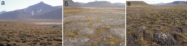
8. Manifestations of cryogenic microrelief in the coastal lowlands of Western Svalbard: a) peat hummocks; b) fractured polygonal complexes; c) medallion spots. Peat hummocks occupy large areas within floodplains and low sea terraces. The hummockiness forms the heterogeneity of the depth of seasonal thawing at the nano- and micro-levels. The height differences do not exceed 5 cm. The role of stalk ice in the formation of hummocks is especially noticeable in the conditions of the close location of an open water source in wells and shallow lakes (Fig. 8). Discussion Soil-geomorphological structure and geocryological conditions of the territory The alternation of marine transgressions and glacial accumulation is presumably the reason for the formation of multi-layered sediments on low-lying areas of accumulative seashores. Thus, according to B.R. Mavlyudov and A.V. Kudinov [45], one of the largest glaciers near the hall. During the 20th century, the Grenfjord - Aldegonda retreated from the coast by about 4 km, thereby exposing a significant area on which soil development can currently be observed from the "zero moment" of soil formation [12]. As a result of sea level rise, a layer of sea sands and sandy loams, sometimes containing plant detritus, was deposited on top of glacial deposits (loams with inclusions of pebbles and gravel). Then, with the retreat of the sea, activation of glaciation and a new expansion of the boundaries of the periglacial zone, glacial material is re-deposited. This sequence, repeated several times in a relatively short time, leads to the formation of contrasting layers inside soil profiles with different lithological composition and structural features [30]. Satellite images of the territory of the key section "Southern Shore of the Gulf of Gren Fjord" show 7 large cones of outflow, which also arose as a result of the activity of temporary watercourses (Fig. 2). The marine accumulative shore outside the cones of outflow is formed by overburden processes. This is evidenced by the findings of a large number of fragments of wood. However, the relatively low values of groundwater mineralization in the soil sections SVB-24-02 and SVB-24-07 (TDS = 179.1 and 350 mg/L, respectively) indicate the absence of a stable hydraulic connection between marine and groundwater at the present time. Presumably, the absence of signs of salinization here is also due to the washing water regime of the soils. The low floodplain is composed of light and medium loamy sediments (Fig. 2A). Judging by the presence of tacular crusts on the surface (covered in a dry state with a network of small polygonal cracks) with whitish discolorations of mineral salts (presumably of a sodium chloride composition), they are significantly influenced by sea waters. All relief levels in the Cape Finniset area, including the II glacial-marine accumulative terrace, are cut through by a stream, the course of which is apparently temporary, since its waters are formed by snowfall on the bedrock slope of the east coast of the Grenfjord. The involvement of the sea in the formation of these sediments, as well as the underlying layer of loam, is evidenced by the findings of bivalve shells and their fragments [46]. Presumably, the depletion of the species composition of plant associations observed at all four sites during the transition from EGL on loamy soils to EGL on lighter, including gravelly deposits, is associated with a shortage of fine earth within the root layer, as well as with the occurrence of groundwater levels no deeper than 30-40 cm from the soil surface. The landscapes of low accumulative seashores were formed with the significant participation of marine accumulation of saline loamy sediment, which confirms the presence of a thin crust of salt fading on the soil surface (Fig. 2A). In addition, groundwater exposed by the SVB-24-14 and SVB-24-15 soil sections has increased mineralization, with TDS values of 197 and 3040 mg/l, respectively. Such landscapes have limited potential for the growth of most plants, giving way to a dominant position of solyanka. Wells drilled in the Adventdalen Valley (Longyearbyen area) in loose deluvial sediments often exposed a series of highly silty layers of ataxite cryotexture, including those typical for thicknesses saturated with crushed stone and pebbles [26]. The capacity of the STS, recorded by analyzing the course of thermometric observations for 2010-2011 in the Adventdalena well, is about 75 cm, with a small low-ice stratum below, and a high-ice stratum below (presumably the transition layer of the MMP). The Adventdalen well is located on the gentle slope of the northern exposure of the valley of the same name, and in the Endalen well, under similar conditions, but in the southern exposure, it thaws annually to about 170 cm, and the high-ice thickness of the transition layer is presumably almost completely degraded [47-48].
The results of long-term remote sensing of the degree of severity of cryogenic microrelief [48] generally indicate its almost widespread degradation, especially at low geomorphological levels. Nevertheless, in the deep hollows of the runoff on the northern slopes, there are areas where, over the period 2009-2017, the average thawing time per year decreased, and therefore the depth of the STS, as a result of which a neoplasm of MMP may occur. Variation of physical and chemical properties of natural waters The pH values of natural waters, including groundwater, increase by almost 1 unit as they move from the upper part of the catenary profile to the lower one. This is due to the significant role of marine waters in the formation of the physico-chemical properties of soils in the lower relief levels and the almost complete absence of their modern influence on the formation of soil properties on high river and sea terraces. These areas are formed with the significant participation of surging movements of seawater, which lead to significant salinization of these sediments, on the surface of which there is no vegetation, and in the dry state, whitish salt fading is observed. The high floodplains are composed of coarse alluvial-marine sand with a high content of coarse-grained fraction, presumably of glacial origin. At the present stage of soil formation, gray humus calcified gley soil is developing here. A profile is located below it, presumably left over from the previous stage of soil formation, when a sulfide salt marsh was formed in this area. Its structure is quite close to those described at points SVB-24-03 and SVB-24-15 (Fig. 6). In the upper part of the buried profile, there is a barely noticeable interlayer at a depth of about 43-45 cm from the surface, probably formerly the SS horizon (salt marsh takyriform crust). Depending on the point of view, it is also possible to interpret this section as containing two buried profiles at once. In this case, its structural formula can be written as: AY – [SSg – GCOX – Gss] – [SS – GsC – Gss]┴ – C┬. According to this interpretation, the first buried profile is a sulfide salt marsh, and below it lies a second almost similar salt marsh. The most alkaline are seawater, with pH values ranging from 8.1 to 9.2 units. It is the type of water that causes the greatest differences in the acidity of the environment of elementary landscapes – proximity to the sea and the presence of a stable hydraulic connection of land waters with sea waters leads to the fact that in the groundwater of some coastal landscapes the reaction of the environment is alkaline (section SVB-24-08, etc.). The maximum pH value is 9.2 units. at the same time, it is typical for water in backwaters that do not have constant water exchange with the sea, and some of the lowest values are observed in soils whose sections were laid on elevated terrain at a distance from the coast – SVB-24-06 (pH 7.2), SVB-24-13 (pH 6.7) and others . The pH values vary relatively slightly between the key study sites, the average values differ from each other by 0.2 – 0.3 units, while the variation intervals practically coincide (Table 2). There is no obvious pattern of an increase or decrease in the average pH value up or down the model geochemical catena. The coefficient L differs slightly from 1 throughout the entire EGL series (Fig. 9). Eh values show a fairly wide range from -3 to 246 mV. The entire range of values is characteristic of the reducing environment ( The most important factor in differentiating TDS values is the type of waters, which in this case determines the variation of both average and maximum TDS values. Practically fresh waters (TDS no more than 0.05 g / l) are distinguished by snow and ice, slightly higher mineralization of lake and river waters, the variation in TDS values of which is explained by the different ratios of atmospheric (or glacial) and seawater, which form the chemical composition of a particular landscape. Thus, in the soils of sites located in close proximity to the sea, TDS values often exceeded 3.0 g/l (Table. 9), whereas the waters protruding in the soils studied on elevated terrain were close to fresh. A steady increase in TDS values is noticeable down the catena. 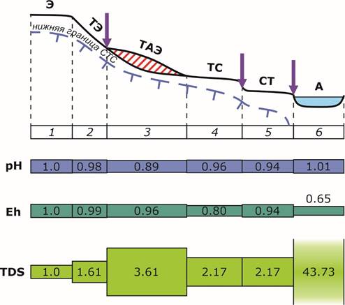
9. General patterns of catenary distributions of the physico-chemical properties of natural waters in the areas of Western Svalbard studied in 2024. Geomorphological levels: 1 – watersheds and automorphic surfaces of terraces; 2 – steep slopes of terraces; 3 – gentle slopes, including on deluvial plumes; 4 – high floodplains; 5 – low floodplain; 6 – water bodies. Elementary geochemical landscapes: E – eluvial; TE – transeluvial; TAE – transaccumulative-eluvial; CT – superaqueous-transit; TC – transit-superaqueous; A – aquatic. The red oblique hatching shows the deluvial plume, the arrows show the locations of the lateral geochemical barriers. Conclusion The structure of most of the cryogenic soils studied in the coastal-marine ecosystems of Western Svalbard reveals the presence of contrasting layers within soil profiles with different lithological composition and structural features, due to the alternation of marine transgressions and glacial accumulation at the current climatic stage of development. The cryogenic microrelief currently developed corresponds to the current climatic conditions to a very small extent and is relatively poorly supported by modern cryogenic processes. The increase in the capacity of the JTS also explains the almost widespread degradation of the upper, transitional layer of the MMP, however, large-scale landscape alterations are not expected in most of the territory, due to the shallow occurrence of rocks. The role of marine waters in the formation of modern physico-chemical properties of soils is leading at the lower levels of the mesorelief and practically does not manifest itself in the properties of soils on high river and sea terraces.
In the soil and landscape geochemical catenae of the studied key sites in Western Svalbard, it is most likely to detect regenerative lateral geochemical barriers that develop due to a sharp drop in soil Eh values at the boundaries between high and low floodplains, as well as between sites more and less affected by overburden processes and marine accumulation. Given the marine accumulation of fine silty particles in these zones, it is also possible to assume the complex nature of these barriers and classify them as reducing-sorption. In this case, it is these areas of low accumulative seashores that will have an increased potential for accumulation of various chemicals, including potentially toxic ones. Given the presence of a large amount of organic detritus, this potential can increase significantly. It is these zones that may be of increased interest for future ecological and geochemical research.
References
1. Humlum, O., Instanes, A., & Sollid, J.L. (2003). Permafrost in Svalbard: a review of research history, climatic background and engineering challenges. Polar Research, 22(2), 191-215.
2. Vtyurin, B.I. (1989). Underground ice of Spitsbergen. Materialy glatsiologicheskikh issledovaniy. Khronika, obsuzhdeniya (Proceedings of glaciological research. Chronicles, discussions), 65, 69-75.
3. Vtyurin, B.I. (1990). Cryogenic structure of Spitsbergen soft sediments. Materialy glatsiologicheskikh issledovaniy. Khronika, obsuzhdeniya (Proceedings of glaciological research. Chronicles, discussions), 70, 43-49. (in Russian)
4. Geologien på Svalbard. (2007). S. Elvevold, W. Dallmann, D. Blomeier. Norge, Tromsø: Norsk Polarinstitutt, Polarmiljøsenteret. ISBN: 978-82-7666-239-9. (in Norge)
5. Krotkov, V.E., Pismenyuk, A.A., & Kizyakov, A.I. (2019). Territorial differentiation of cryogenic processes occurrence on the Nordenskiold Land (West Spitsbergen island). Relief I chetvertichniye obrazovania Arktiki, Subarktiki I Severo-Zapada Rossii (Terrain and Quaternary formations of the Arctic, Sub-Arctic and North-West of Russia), 6, 66-70. Retrieved from https://doi.org/10.24411/2687-1092-2019-10611
6. Osokin, N.I., Sosnovskiy, A.V., Nakalov, P.R. et al. (2012). Climate changes and possible dynamics of permafrost in Spitsbergen archipelago. Ice and Snow, 2(118), 115-120.
7. Schirrmeister, L., Siegert, C., & Strauß, J. (2012). Permafrost ein sensibles Klimaphänomen – Begriffe, Klassifikationen und Zusmmenhänge. Polarforschung, 81(1), 3-10. (in German)
8. Targulian, V.O., & Kulikov, A.V. (1983). Main features of soils of the West Spitsbergen island. “Biological problems of the North”. Proc. of the X Symposium of the USSR. Pt. 1. Magadan. P. 272-273.
9. Dobrovol’skiy, V.V. (1990). Spitsbergen soil geochemistry. Pochvovedenie (Soil Science), 2, 5-20.
10. Pereverzev, V.N., & Litvinova, T.I. (2010). Soils of marine terraces and core slopes of the Western Spitsbergen island fjord coasts. Pochvovedenie (Soil Science), 3, 259-269.
11. Kriauchunas, V.V., Iglovsky, S.A., Shakhova, E.V., & Malkov, A.V. (2014). Heavy metals in Arctic soils of the Western coast of Spitsbergen archipelago. Ekologiya cheloveka (Human ecology), 9, 8-13.
12. Alekseev, I.I., & Abakumov, E.V. (2016). Taxonomical and morphological diversity of soils across Green Fjord bay (Spitsbergen archipelago). Samarskaya Luka: problem regional’noy I global’noy ekologii (Samara Luka: problems of regional and global ecology), 4, 156-161.
13. Kashulina, G.M., Litvinova, T.I., & Korobeynikova, N.M. (2021). Soils of the South-Western coast of Western Spitsbergen island. Izvestia Kol’skogo Nauchnogo Tsentra RAN. Prikladnaya ekologiya Severa (Proceedings of the Kola Scientific Center RAS. Applied ecology of the North), 6, 271-275. Retrieved from https://doi.org/10.37614/2307-5252.2021.6.12.9.040
14. Walker, D.A., Raynolds, M.K., Daniels, F.J.A. et al. (2005). The Circumpolar Arctic Vegetation Map. J. Veg. Sci., 3, 267–282. Retrieved from https://doi.org/10.1111/j.1654-1103.2005.tb02365.x
15. Szymański, W., Skiba, S., & Wojtun, B. (2013). Distribution, genesis, and properties of Arctic soils: a case study from the Fuglebekken catchment, Spitsbergen. Polish Polar Research, 3, 289-304. Retrieved from https://doi.org/10.2478/popore−2013−0017
16. van der Meij W.M., A.J.A.M. Temme, C.M.F.J.J. de Kleijn, T. Reimann, G.B.M. Heuvelink, Z. Zwoliński, G. Rachlewicz, K. Rymer, M. Sommer (2016). Arctic soil development on a series of marine terraces on central Spitsbergen, Svalbard: a combined geochronology, fieldwork and modelling approach. SOIL, 2, 221-240. Retrieved from https://doi.org/10.5194/soil-2-221-2016
17. Bartos, A., Szymański, W., & Gus-Stolarczyk, M. (2023). Morphology and properties of permafrost-affected soils under different tundra vegetation in central Spitsbergen. Polish Polar Research, 1, 1-20. Retrieved from https://doi.org/10.24425/ppr.2022.143317
18. Jones, E.L., Hodson, A.J., Thornton, S.F., Redeker, K.R., Rogers, J., Wynn, P.M., Dixon, T.J., Bottrell, S.H., & O’Neill, H.B. (2020). Biogeochemical Processes in the Active Layer and Permafrost of a High Arctic Fjord Valley. Front. Earth Sci., Vol. 8, 342. Retrieved from https://doi.org/10.3389/feart.2020.00342
19. Shlyakhov, S.A. (1996). Klassifikatsiya pochv morskikh poberezhiy (Classification of soils of the sea coasts). Vladivostok.
20. Chernousenko, G.I., Oreshnikova, N.V., Ukraintseva, N.G. (2001). Salinization of soils of the Russian Arctic seas Northern coasts. Pochvovedenie (Soil Science), 10, 1192-1206.
21. Gubin, S.V., Lupachev, A.V., Khodzhaeva, A.K. (2022). Soils of accumulative sea costs of the Russian Arctic North-Eastern sector. Pochvovedenie (Soil Science), 1, 1-8. Retrieved from https://doi.org/10.31857/S0032180X22010051
22. Lupachev, A.V., & Gubin, S.V. (2023). The soil-cryogenic complex: Evidence of late Pleistocene-Holocene coevolution of permafrost and cryosols at the Kolyma Lowland. Permafrost and Periglac. Process, pp. 1-14. Retrieved from https://doi.org/10.1002/ppp.2191
23. Shur, Yu.L. (1988). Verkhniy gorizont tolshchi merzlykh porod I termokarst (Upper horizon of permafrost and thermokarst). Novosibirsk: Izdatel’stvo Akademii Nauk SSSR. Sibirskoye otdelenie (AS USSR Press. Siberian branch).
24. Andreeva, E.S., Lipovitskaya, I.N., Andreev, S.S. (2019). Modern features of weather-climatic regime of the Western Spitsbergen island ant their input in the solution of anthropogenic traces. Obshchestvo. Sreda. Razvitie (Society. Environment. Development), 2, 68-72.
25. Lavrentiev, I.I., Kutuzov, S.S., Glazovskiy, A.F. et al. (2018). Thickness of snow cover on Eastern Green Fjord glacier (Spitsbergen) by the data of radar measurements and standard snow-measuring surveys. Ice and Snow, 1, 5-20. Retrieved from https://doi.org/10.15356/2076-6734-2018-1-5-20
26. Tolgensbakk, L., Sørbel, J., & Høgvard K. (2000). Adventdalen, Geomorphological and Quaternary Geological map, Svalbard 1:100 000, Spitsbergen sheet C9Q. Norsk Polarinstitut Temakart rr. 32.
27. Sharin, V.V., Gusev, E.A., Zykov, E.A. (2022). Map of Quaternary formations of the Spitsbergen archipelago scaled 1:1000 000. Relief I chetvertichniye obrazovania Arktiki, Subarktiki I Severo-Zapada Rossii (Terrain and Quaternary formations of the Arctic, Sub-Arctic and North-West of Russia), 9, 291-295. Retrieved from https://doi.org/10.24412/2687-1092-2022-9-291-295
28. Bondevik, S., Mangerud, J., Ronnert, L. et al. (1995). Postglacial sea-level history of Edgeoya and Barentsoya, eastern Svalbard. Polar Res., 14(2), 153-180.
29. Geoscience Atlas of Svalbard. (2015). Ed. W.K. Dallmann. Norway, Tromsø: Norsk Polarinstitutt (Norge Polar Institute), Report Series, 148, 292.
30. Terekhov, A.V. (2024). Variability of the Barentsburg area glaciers mass balance (Spitsbergen archipelago) in the starting of the 21st century. PhD in Geography thesis. SPb: Arctic & Antarctic Research Institute.
31. Landvik, J., Mangerund, J., & Salvigsen, О. (1988). Glacial history and permafrost in the Svalbard area. V Intern. on Permafrost, p. 194-198. Trondheim, Norway.
32. Oledenenie Spitsbergena (Svalbarda) (Glaciation of Spitsbergen (Svalbard)). (1975). Moscow.: Nauka (Science). (in Russian)
33. Brown, J., Ferrians Jr., Heginbottom O.J. et al. (1997). Circum-Arctic Map of Permafrost and Ground-Ice Conditions. US Geological Survey Reston.
34. Etzemüller, B., Schuler, T.V., Isaksen, K., Christiansen, H.H., Farbrot, H., & Benestad, R. (2011). Modeling the temperature evolution of Svalbard permafrost during the 20th and 21st century. Cryosphere, 5, 67-79. Retrieved from https://doi.org/10.5194/tc-5-67-2011
35. Harris, C., Kern-Luetschg, M., Christiansen, H.H. et al. (2011). The Role of Interannual Climate Variability in Controlling Solifluction Processes, Endalen, Svalbard. Perm. Periglac. Proc., 22(3), 239-253. Retrieved from https://doi.org/10.1002/ppp.727
36. Romanovsky, V.E., Smith, S.L., & Christiansen, H.H. (2010). Permafrost thermal state in the polar Northern Hemisphere during the international polar year 2007–2009: a synthesis. Perm. Periglac. Proc., 21, 106-116.
37. Demidov, N.E., Karaevskaya, E.S., Verkulich, S.R., Nikulina, A.L., & Savatyugin, L.M. (2016). First results of permafrost monitoring on the cryosphere polygon of the Russian Scientific Center on Spitsbergen archipelago (RSCS). Problemy Arktiki I Antarktiki (Arctic and Antarctic research), 4(110), 67-79.
38. Database of the International Circumpolar Active Layer Monitoring program (CALM), data on the measurement results on key sites across the Northern Hemisphere [Digital resource]. Retrieved from https://www2.gwu.edu/~calm/data/north.htm
39. A catalogue of Svalbard plants, fungi, algae and cyanobacteria. (1996). Oslo: Norsk Polarinstitutt.
40. Polevoy opredelitel’ pochv Rossii (Guidebook for the definition of Russian soils). (2008). Moscow: Pochvenniy Institut im. V.V. Dokuchaeva (Dokuchaev Soil Institute). (in Russian)
41. Glazovskaya, M.A. (1964). Geokhimicheskiye osnovy tipologii I metodiki issledovaniy prirodnykh landshaftov (Geochemical basics of typology and methods to study natural landscapes). Moscow: Izdatel’stvo Mosk. un-ta (Moscow University Press.). (in Russian)
42. Bogdanova, M.D., Gavrilova, I.P., & Gerasimova, M.I. (2012). Elementary landscapes as objects of the landscape-geochemical mapping. Vestnik Moskovskogo Iniversiteta. Seria 5. Geografia (Moscow University Bulletin. Series 5. Geography), 1, 23-28.
43. Hacquebord, L. (2001). Three centuries of whaling and walrus hunting in Svalbard and its impact on the Arctic ecosystem. Environment and History, Vol. 7, No. 2, “Beyond Local, Natural Ecosystems” Sp. Iss. Pp. 169-185. Retrieved from https://doi.org/10.3197/096734001129342441
44. Grønfjord (Green Harbour): Finneset. [Электронный ресурс]. Retrieved from https://www.spitsbergen-svalbard.com/photos-panoramas-videos-and-webcams/spitsbergen-panoramas/finneset.html
45. Mavlyudov, B.R., & Kudinov, A.V. (2018). Changes of Aldegonda glaciers from the starting of XX century. Izvestia Kol’skogo Nauchnogo Tsentra RAN. Prikladnaya ekologiya Severa (Proceedings of the Kola Scientific Center RAS. Applied ecology of the North), 3(10), 152-162. Retrieved from https://doi.org/10.25702/KSC.2307-5228.2018.10.3.152-164
46. Kriauchunas, V.V., Iglovsky, S.A., Lyubas, A.A. et al. (2020). New data on paleogeography of Eastern coast of the Green Fjord bay (Western Spitsbergen island) basing on the Holocene sediments study at cape Finneset using isotopic and geochemical methods. Izvestiya Tomskogo Politekhnicheskogo Universiteta. Inzhiniring georesursov (Tomsk Polytechnical University Bulletin. Georesources engineering), 1, 171-183. Retrieved from https://doi.org/10.18799/24131830/2020/1/2458
47. Rassmussen, C.F., Christiansen, H.H., Buylaert, J.P. et al. (2023). High-resolution OSL dating of loess in Adventdalen, Svalbard: Late Holocene dust activity and permafrost development. Quatern. Sci. Rev., 310:108137. Retrieved from https://doi.org/10.1016/j.quascirev.2023.108137
48. Rouyet, L., Laukens, T.R., Christiansen, H.H. et al. (2019). Seasonal dynamics of a permafrost landscape, Adventdalen, Svalbard, investigated by InSAR. Rem. Sens. of Environ. 231:111236. 17 p. Retrieved from https://doi.org/10.1016/j.rse.2019.11123
Peer Review
Peer reviewers' evaluations remain confidential and are not disclosed to the public. Only external reviews, authorized for publication by the article's author(s), are made public. Typically, these final reviews are conducted after the manuscript's revision. Adhering to our double-blind review policy, the reviewer's identity is kept confidential.
The list of publisher reviewers can be found here.
The subject of research in this work is the study of the soil-geomorphological structure, physico-chemical properties of soils and natural waters of western Svalbard. The research methodology is based on laboratory methods of chemical analysis of soils and water samples, as well as field methods of soil sections at key sites with a description of soils according to a field determinant. The soil temperature was measured in 10 cm increments using an automatic probe thermometer. The selection of soil samples was carried out horizontally. The physico-chemical parameters of natural waters of various origins in 26 locations have been studied. Relevance. Cryogenic soils and the underlying upper horizons of permafrost rocks are an essential element of the functioning of polar biomes in areas with a close occurrence of permafrost rocks. The structure, properties, and functioning of the soil cover and permafrost largely determine the geochemical features of polar landscapes. Permafrost rocks of Svalbard are common not only in the highlands, but also in low-lying coastal areas, most heavily occupied by vegetation and exposed to anthropogenic impact, they occupy up to 70% of the area of non-glacial spaces there. The current dynamics of the cryolithozone development in the region, primarily an increase in the thickness of the active layer against the background of an increase in average annual air temperatures, can significantly affect the soils of the coastal–marine cryogenic ecosystems of Svalbard. In this regard, it is relevant to study the soil-geomorphological structure and physico-chemical properties of soils and natural waters of the coastal-marine cryogenic landscapes of western Svalbard. The objects of the study were two key areas – the coast of the Gren Fjord Bay in the area of the village of Barentsburg and the coast of Kolsbey Bay in the Isfjord Bay near the polar station of the same name. 12 soil sections were laid in various landscape-geomorphological and geocryological conditions on the coastal lowlands of the shores of the Gren Fjord Bay, and 4 sections were laid in the area of the Kolsbey peninsula. The scientific novelty lies in the description of the geochemical features of the landscapes, soils and natural waters of western Svalbard. The style of the article is scientific and meets the established requirements of the journal. The structure of the article includes an introduction, objects and methods of research, results and discussion, conclusion, bibliography. The volume of the text part of the article meets the requirements of the journal. In general, the content of the scientific article reveals its topic, the conclusions are evidence-based and substantiated. The text is written in a scientific language, but there are some minor comments on the spelling of the words. For example, in the title of an article, the words "geomorphological" and "western" should be written with lowercase letters, not with capital letters. The bibliography of the article is too extensive and includes 48 sources, 22 of which are in a foreign language. Some sources were published more than 40 years ago, which violates the modern requirements of peer-reviewed journals on the use of literary sources. Several sources are designed in violation of GOST, so the author needs to make adjustments. The conclusions in the article are sufficiently reasoned and substantiated. The author has established that the cryogenic microrelief currently developed corresponds to the current climatic conditions to a very small extent and is relatively poorly supported by modern cryogenic processes. The role of marine waters in the formation of modern physico-chemical properties of soils is leading at the lower levels of the mesorelief and practically does not manifest itself in the properties of soils on high river and sea terraces. In the soil and landscape geochemical catenae of the studied key sites in western Svalbard, it is most likely that regenerative lateral geochemical barriers are being discovered, which develop due to a sharp drop in soil Eh values at the boundaries between high and low floodplains. The scientific article has important practical significance, as the results of the conducted research may be of increased interest for future ecological and geochemical research in western Svalbard. The reviewed article will undoubtedly be interesting and useful to soil scientists, soil scientists and permafrost scientists, as well as scientists and graduate students of these scientific fields. This article is recommended for publication in the journal "Arctic and Antarctic" after revision.
|

 Eng
Eng


